DirectoryENG
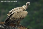
International Douro Natural Park includes the territories of towns such as Figueira de Castelo Rodrigo, Freixo de Espada á Cinta, Miranda do Douro and Mogadouro, totalizing na área of 85.150 hectares, and encloses the border of Rio Douro. The territory of Miranda of the Douro has the privilege to belong to this park, conferring even more value to it, for it is the habitat chosen by many animal species, also offering ideal conditions for proliferation of certain vegetal species. The landscape of Miranda do Douro’s territory is characterized by declivous walls of rock where Rio Douro assumes a structure of fluvial cannon thanks to its geomorphology. It acquires therefore geologic and climatic characteristics conditioning the vegetal and animal population. Avifauna acquires a significant importance on a national and International level and when associated to human activities and the local cultural heritage, all these conditions justify the denomination of this area as NaturalPark of the International Douro.

The area of the mountain ranges of Montesinho and Coroa was chosen as NaturalPark for congregating conditions where the pleasant integration of man with the environment is visible. The MontesinhoNaturalPark was created in 1979, being one of the biggest protected areas of Portugal. With a surface of 75 000 hectares, it includes about 9 000 inhabitants distributed by 92 villages. It is constituted by a succession of mountains and valleys deeply incased, with altitudes varying between 438m and the 1481 m where the villages, nestled in sheltered and discrete points, pass easily unobserved to the eyes of the occasional visitor.
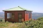
Description: Equipment that intends to preserve, to promote and to interpret the landscape of the region. Situated in the MontesinhoNaturalPark, it allows to a trip for the fauna and flora of the region, in full contact with the nature.
Starting point: Biological park of Vinhais (41,858758, – 6,987669)
Arrived Point of: Top of theCiradelha (41,85927, – 6,987047)
Extension: approximately 1,5km
Level of difficulty: moderate
Time: 2 hours
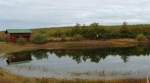
Starting point: Biological park of Vinhais (41,858758, – 6,987669)
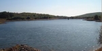
Arriving Point: Vidoeira pond (41,864991, – 6,990438)
Extension: approximately 1,1km
Level of difficulty: easy
Time: 1 hour 30 minuts
Starting point: Biological park of Vinhais (41,858758, – 6,987669)
Arriving Point: Biological park of Vinhais
Extension: approximately 6,5km
Level of difficulty: moderate
Time: 2 hours 30 minutes
Description: The Via Augusta XVII century path in the territory of Vinhais comprehends about 18 km initiating at the limit of the village of Agrochão. Here you can visit the Ethnographic Museum of Agriculture, and also the Olive Oil Museum, located in an old olive oil production unit (lagar), where the visitor takes knowledge of the process of manufacture of this ancient alimentary condiment.
Starting point: limit of the village of Agrochão passing south of the Cabeço de Marco
Arriving Point:village of Agrochão
Extension: approximately 18km
Level of difficulty: moderate
Time: 5hours 30 minutes
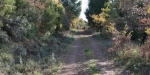
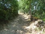
Description: The Ciradelha Path, is a small pedestrian route (PR) of pleasant landscapes that goes along agricultural trails thru the territory of Vinhais. It has an extension of 9km with altitudes understood between 650m and 1000m and an average level of difficulty, corresponding about 3 hours and 30 minutes of walking.
Starting point: Vinhais (coordinates GPS)
Arriving Point: Vinhais
Extension: approximately 9km
Level of difficulty: moderate
Time: 3hours 30 minuts
Description: This is a small pedestrian path of (PR) passing thru agricultural landscape of the Vinhais territory. It presents an extension of 4,8km with altitudes understood between 610m and 720m and an average level of difficulty, corresponding about 2 hours of walking.
Starting point: Vinhais (coordinates GPS)
Arriving Point: Vinhais
Extension: approximately 4,8km
Level of difficulty: moderate
Time: 2hours

Description: This is a small pedestrian passage (PR) that crosses the territory of Pinheiro Novo. With and extension 12Km, with altitudes understood between 830m and 1149m and a moderate to high level of difficulty and corresponding about 5 hours of walking.
Starting point: Pinheiro Novo
Arriving Point: Pinheiro Novo
Extension: approximately 12km
Level of difficulty: moderate
Time: 5 hours